Conditions & Terrain
Bike Park Report
Mt Washington Alpine Resort
Bike Park Report
Second Sneak PEAK Weekend Coming Up!
Mount Washington is closed this week as we prepare for our second Sneak Peak weekend, June 20 – 21! 10% off Bike Park day tickets this weekend! Join us for more mountain biking, ZipTours, and summer fun.
Updated: 2026-06-19 – 10:08 AM
Weather
Right Now
Clear
Fri 19
H: 12° c
L: 9° c
Sat 20
H: 13° c
L: 12° c
Sun 21
H: 16° c
L: 14° c
| Summer Lifts | Status & Info | Hours |
|---|---|---|
| EAGLE | CLOSED | |
| HAWK | CLOSED | |
| ZIPTOUR | CLOSED |
Bike Park Update
We are now closed
Bike Park Trails
Greenline
| Distance | Ability | Status | Style |
|---|---|---|---|
| 3.5 kms |  |
Trail suitable for beginner and intermediate riders with gentle terrain, sweeping berms and a few small rollovers. Confidence and conditioning can be built up riding this trail, and experienced riders need to be aware of new beginners. Please take it slow and be aware of all others riding around you.
TRAILFORKS WIDGET START
Greenline on Trailforks.com TRAILFORKS WIDGET END
Panda Gardens
| Distance | Ability | Status | Style |
|---|---|---|---|
| 0.3 kms | |
Beginner trail with fun flowy berms.
TRAILFORKS WIDGET START
Panda Gardens on Trailforks.com TRAILFORKS WIDGET END
HWY 19
| Distance | Ability | Status | Style |
|---|---|---|---|
| 2.8 kms |  |
This trail is the next step in your progression to steeper grades. With slightly steeper terrain, it offers riders a natural progression to more advanced skills.
TRAILFORKS WIDGET START
HWY 19 on Trailforks.com TRAILFORKS WIDGET END
Call It In
| Distance | Ability | Status | Style |
|---|---|---|---|
| 1.3 kms |  |
Progression to steeper grades with more difficult obstacles offers riders a natural progression to more advanced skills.
TRAILFORKS WIDGET START
Call It In on Trailforks.com TRAILFORKS WIDGET END
Blue Hammer
| Distance | Ability | Status | Style |
|---|---|---|---|
| 0.7 kms | |
Fun flow trail with berms, roller jumps, tables, and a rock ride feature.
TRAILFORKS WIDGET START
Blue Hammer on Trailforks.com TRAILFORKS WIDGET END
Step Brother
| Distance | Ability | Status | Style |
|---|---|---|---|
| 0.2 kms | |
Short but sweet! Our latest new fun flow trail that can be accessed off Hwy 19 is now open.
TRAILFORKS WIDGET START
Step Brother on Trailforks.com TRAILFORKS WIDGET END
Hustler
| Distance | Ability | Status | Style |
|---|---|---|---|
| 1.6 kms | |
Hustler features large berms, bridges, tables and large roll-overs along with over a km of flow to get you stoked! A Blue Flow Trail offering Black-Diamond features with ride-around options.
TRAILFORKS WIDGET START
Hustler on Trailforks.com TRAILFORKS WIDGET END
Osezno
| Distance | Ability | Status | Style |
|---|---|---|---|
| 1.5 kms | |
The Blue Flow trail, designed and built by Darren (Bearclaw) Berrecloth.
TRAILFORKS WIDGET START
Osezno on Trailforks.com TRAILFORKS WIDGET END
Helter Skelter
| Distance | Ability | Status | Style |
|---|---|---|---|
| 1.3 kms | |
Technical trail type offering single-track descent with steep grades and tight turns.
TRAILFORKS WIDGET START
Helter Skelter on Trailforks.com TRAILFORKS WIDGET END
Little Blue
| Distance | Ability | Status | Style |
|---|---|---|---|
| 0.4 kms | |
Inspired by our friends in Cumberland this blue square tech trail features a small waterfall, a creek and great alpine views of Strathcona Park. A great addition for riders to access the Hawk chair from the lodge.
TRAILFORKS WIDGET START
Little Blue on Trailforks.com TRAILFORKS WIDGET END
The Wiz Upper
| Distance | Ability | Status | Style |
|---|---|---|---|
| 0.4 kms |  |
This trail has the 3 R’s, roots, rocks, and rollovers. Be aware of crossing at Greenline and yield to slower riders.
TRAILFORKS WIDGET START
The Wiz Upper on Trailforks.com TRAILFORKS WIDGET END
The Wiz Lower
| Distance | Ability | Status | Style |
|---|---|---|---|
| 0.5 kms | |
The second section of the Wiz. Steep flowy berm sections with some jumps.
TRAILFORKS WIDGET START
The Wiz Lower on Trailforks.com TRAILFORKS WIDGET END
Time Warp
| Distance | Ability | Status | Style |
|---|---|---|---|
| 1.5 kms | |
Steep flowy berm sections with some large jumps and step-ups. New drop feature, you’ll find this new drop just before Time Warp joins the Monster Mile.
TRAILFORKS WIDGET START
Time Warp on Trailforks.com TRAILFORKS WIDGET END
Lower Time Warp
| Distance | Ability | Status | Style |
|---|---|---|---|
| 0.4 kms | |
Lower Time Warp! Access off Monster/Hawk Connector or via Disco road. Inspired by the former 4-Cross and Bear Claw Invitational, this black diamond trail has large features and flow giving advanced and expert riders fall line to the Hawk Chair.
TRAILFORKS WIDGET START
Lower Time Warp on Trailforks.com TRAILFORKS WIDGET END
Back In Black
| Distance | Ability | Status | Style |
|---|---|---|---|
| 1.9 kms |  |
Entrance closed for rebuilding. Look for the new rock roll on riders left near mid section of Back in Black. Watch for, drops and other features. All features have a ride-around option. Full armour and a high degree of skill are strongly suggested for the most advanced riders.
TRAILFORKS WIDGET START
Back In Black on Trailforks.com TRAILFORKS WIDGET END
Upper Helter Skelter
| Distance | Ability | Status | Style |
|---|---|---|---|
| 0.2 kms |  |
Now starting from the top of the Hawk chairlift and connecting to the lower sections to make one technical trail.
TRAILFORKS WIDGET START
Upper Helter Skelter on Trailforks.com TRAILFORKS WIDGET END
Riptide Ridge
| Distance | Ability | Status | Style |
|---|---|---|---|
| 0.9 kms |  |
Loamy handcrafted sub-alpine tech trail featuring amazing views, flowy sections, rock gardens and more!
TRAILFORKS WIDGET START
Riptide Ridge on Trailforks.com TRAILFORKS WIDGET END
Straight Shot
| Distance | Ability | Status | Style |
|---|---|---|---|
| 0.2 kms | |
A short advanced tech trail to start your day or end your last run on the way to the Hawk chairlift.
TRAILFORKS WIDGET START
Straight Shot on Trailforks.com TRAILFORKS WIDGET END
Salami Hands
| Distance | Ability | Status | Style |
|---|---|---|---|
| 0.5 kms | |
A short tech trail connecting Hustler to the Alpine Lodge.
TRAILFORKS WIDGET START
Salami Hands on Trailforks.com TRAILFORKS WIDGET END
Upper Monster Mile
| Distance | Ability | Status | Style |
|---|---|---|---|
| 0.9 kms | |
Experts only on this technical double-black trail with unbeatable views from the top of Eagle Chairlift.
TRAILFORKS WIDGET START
Upper Monster Mile on Trailforks.com TRAILFORKS WIDGET END
Monster Mile
| Distance | Ability | Status | Style |
|---|---|---|---|
| 1.4 kms | |
A steep and gnarly technical trail only meant for advanced riders. The mountain’s signature old-school freeride trail. If you are unfamiliar with this trail, make sure you look first before rolling onto a feature.
TRAILFORKS WIDGET START
Monster Mile on Trailforks.com TRAILFORKS WIDGET END
Eagle Skills Area
| Distance | Ability | Status | Style |
|---|---|---|---|
| 0.0 kms | SKILLS ZONES |
Located between the Alpine Lodge and Hawk Chair. The Eagle Skills area was designed to build confidence and familiarize riders with our bike park. This area contains a small drop zone as well as berms and rollers similar to those you’ll find on the mountain trails.
TRAILFORKS WIDGET START
Eagle Skills Area on Trailforks.com TRAILFORKS WIDGET END
Hawk Skills Area
| Distance | Ability | Status | Style |
|---|---|---|---|
| 0.0 kms | SKILLS ZONES |
Located at the corner of the Finger Trail and Back in Black.
TRAILFORKS WIDGET START
Hawk Skills Area on Trailforks.com TRAILFORKS WIDGET END
Finger Trail
| Distance | Ability | Status | Style |
|---|---|---|---|
| 7.5 kms | |
This trail can be accessed without a chair lift ride, however, a waiver and free pass need to be picked up at the Alpine Lodge prior to entering the bike park. The mountain’s signature XC trail, delivering challenging terrain and providing unparalleled views of Strathcona Provincial Park. Steeper grades with more difficult obstacles offer riders a natural progression to more advanced XC skills.
TRAILFORKS WIDGET START
Finger Trail on Trailforks.com TRAILFORKS WIDGET END
Finger Trail Bi-Pass
| Distance | Ability | Status | Style |
|---|---|---|---|
| 0.5 kms | |
Short bypass route
Finger Access Road
| Distance | Ability | Status | Style |
|---|---|---|---|
| 1.6 kms | |
Multi-use trail and access road for our XC trails on the far west of our trail network. This is our main multi-use trail access for our Finger trail.
TRAILFORKS WIDGET START
Finger Access Road on Trailforks.com TRAILFORKS WIDGET END
Great Big View
| Distance | Ability | Status | Style |
|---|---|---|---|
| 0.3 kms | |
Multi-use trail overlooking the Raven Lodge and providing spectacular views of the Strathcona Park.
TRAILFORKS WIDGET START
Great Big View on Trailforks.com TRAILFORKS WIDGET END
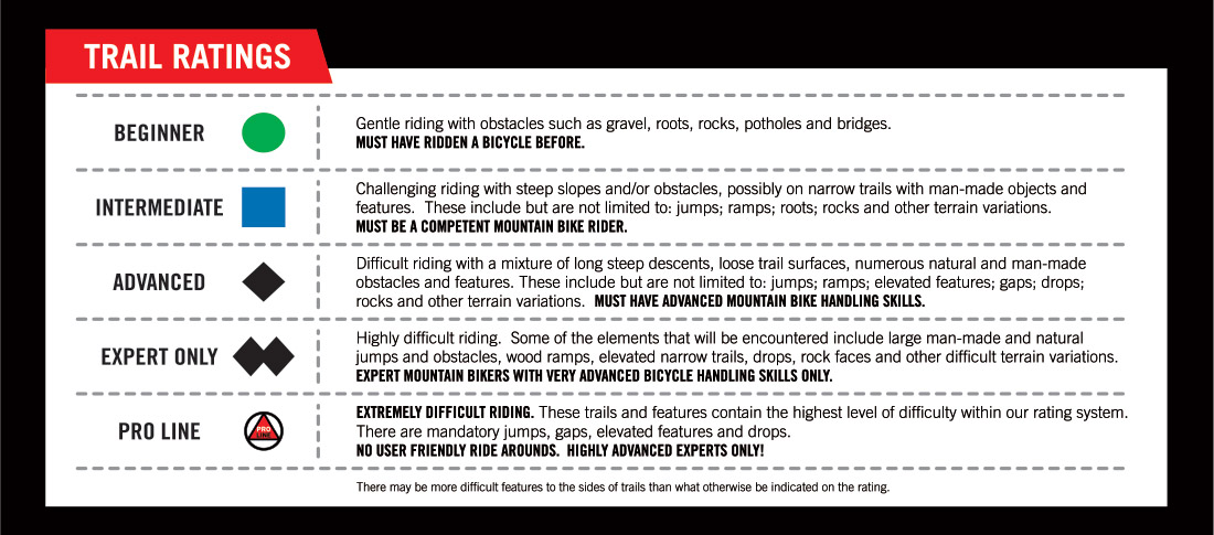
Understanding Bike Park Signage
–
Summer Lifts
Status
Info
Hours
EAGLE
Closed
HAWK
Closed
ZIPTOUR
Bike Park
Bike Park Hours
Days
Time
Period
VI BIKE FESTIVAL AUGUST 22 – 25
Stevie Smith Memorial DH Canada Cup
VI Bike Festival invites the enthusiasts, the casual cyclists, the curious and the energetic to partake in activities and events all throughout the weekend. The Bike Park, Zipline Tours, Sightseeing and more attractions are open throughout race festivities. Music in the Mountains takes to the stage on Saturday afternoon from 3 – 5 pm, featuring Oktiv6 and Funkyard, followed by the Whip Off presented by Forbidden Bikes with tunes from local DJ and staff member Alpine Ambiance. Sunday is the main event, the annual Stevie Smith Memorial DH Race, and spectators are encouraged to cheer on racers tackling the gnarly Monster Mile trail. Click to view the full schedule and more details.
Bike Park
Preview your entire ride from top to bottom.
Download or view our Bike Park map to preview your entire ride. To reduce paper waste, and be sustainable we would invite our guests to utilize the Trailforks app to navigate the bike park, or download this map and keep it on their device. If you require a printed version of this map save it and print as needed.
All routes within the Bike Park are designated by colour-coded trail markers at the start of each descent. Trails with an orange oval indicate freeride trails with man-made features and may require jumping skills. Work your way up to more advanced trails and features based on your progression, skill and comfort level.
Conditions & Terrain
Trail Maps
Alpine Maps
Nordic Maps
Nordic Trail Map (PDF)
Snowshoe & Fatbike Trail Map (PDF)
Nordic Map Complete (PDF)
Summer Maps